
Explore the Earth, Maps and Satellite Images

Google Maps and Google Earth are very common platforms today to explore maps and satellite images of the earth. But there are many other ways to explore the earth. Some are listed here.  1.   Earth Explorer This map is developed by USGS helpful to obtain earth imagery across available geo-spatial data types. Users can navigate via interactive map or text search to obtain Landsat satellite imagery, Radar data, UAS data, digital line graphs, digital elevation model data, aerial photos, Sentinel satellite data, some commercial satellite imagery including IKONOS and OrbView3, land cover data, digital map data from the National Map, and many other datasets. Users can search by exact location via the interactive map or input specific coordinates to view what data types are available. 2.   Sentinel Hub This platform developed by  Sinergise has Sentinel, Landsat, and other Earth observation imagery easily accessible for browsing, visualization and analysi...

Lamuni- Danpur Landslide, Purchaudi Municipality-8, Baitadi District.


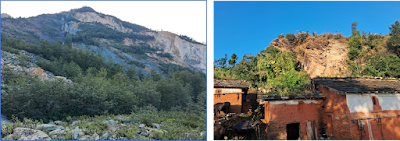
The landslide is located at Lamuni-Danpur area, Purchaudi Municipality-8 of Baitadi District, Sudurpaschim Province.

The Lamuni-Danpur landslide covers about 0.8 sq.km as traced on recent google image. Three villages, Lamuni on east, Danpur on west and Tudet on north are affected due to landslide. As per locals, the landslide is more than 100 years old. About 110 houses have been shifted till now along with loss of cultivable land. The landslide covers forest area of two community forests, Gopeswor Community Forest, Lamuni and Devsthal Community Forest, Danpur. Kedar temple lies about 90m away from the south west part of the landslide. Presently, the landslide is extending toward the Lamuni Village. Some crown cracks has been developed Nearby Lamuni Village. The people residing there are posing great threat of landslide.

The lithology within landslide was dominated by light grey to green phyllite with some quartzite and schist. The Phyllite Unit is overlain by Quartzite and Schist Unit. Based on the regional geology of the area, thrust separates these two units. Overall the beds are north dipping and the general dip amount is ranges from 28-40 o.  The dipping of the bed/foliation is along the hill slope and most of beds are gently dipping than the hill slope which favored the failure. Lithology and thrust may have significant contribution to the occurrence and progression of the landslide.


Fig: Lamuni-Danpur Landslide displayed in the regional geological map.


Fig: Topographical Map showing the Lamuni-Danpur Landslide.


Comments

Popular posts from this blog

Geological Maps of Nepal

  List of geological maps different parts of Nepal . Geological Map of Nepal Geological Maps Of Seven Provinces, Nepal Geological Map of Kathmandu Area and Central Mahabharat Range (Stocklin and Bhattarai, 1980) Photogeological Map of Central Nepal (Stocklin and Bhattarai, 1982). Geological maps of 1:50,000  of different parts of Nepal published by DMG. Engineering Geological and Environmental maps of different cities of Nepal published by DMG. Mineral Resources map of Nepal Epicenter map of Nepal Himalaya

Explore the Earth, Maps and Satellite Images

Google Maps and Google Earth are very common platforms today to explore maps and satellite images of the earth. But there are many other ways to explore the earth. Some are listed here.  1.   Earth Explorer This map is developed by USGS helpful to obtain earth imagery across available geo-spatial data types. Users can navigate via interactive map or text search to obtain Landsat satellite imagery, Radar data, UAS data, digital line graphs, digital elevation model data, aerial photos, Sentinel satellite data, some commercial satellite imagery including IKONOS and OrbView3, land cover data, digital map data from the National Map, and many other datasets. Users can search by exact location via the interactive map or input specific coordinates to view what data types are available. 2.   Sentinel Hub This platform developed by  Sinergise has Sentinel, Landsat, and other Earth observation imagery easily accessible for browsing, visualization and analysi...

Geology Of Nepal

The Himalaya was formed due to collision of Indian Plate and Eurasian Plate at about 40 million years ago. It extends in 2400km east - west direction. Its width varies from 230 to 320 km and bounded between the Indo-Gangetic Plain in the south and Tibetan Plateau in the north. Nepal Himalaya occupies the central 800km part. Heim & Gansser 1939 , and Gansser 1964 divided the rocks of the Himalaya into four tectonostratigraphic zones that are characterised by distinctive stratigraphy and physiography. From south to north, it can be divided into five latitudinal morpho-tectonic zones and these are : 1. The Gangatic Plain (Terai) 2. The Sub Himalayan (Chure or Siwalik) 3 Lesser Himalayan (Mahabharat Mountain Range), 4. Greater Himalayan, and 5. Tibetan Himalayan zones (Tethys Himalaya). Each of these zones is clearly identified by their morphological, geological and tectonic features. Main Frontal Thrust (MFT), Main Boundary Thrust (MBT), Main Central Thrust (MCT) and South Tibetan ...